The Lycian Way represents one of the best hiking spots in the world, with stunning vistas and endless history accompanying travelers across hundreds of kilometers. Whether you’re doing all of it or just so of it, you’re going to need to know what it is you’re hiking! Here are some quick facts to get you started.
What is Lycia?

Lycia means the "Land of Light," and it dates back to the 13th century BC. The Lycian Federation was formed of 77 ancient cities, including Olympos, Xanthos, Patara, Antiphellos, Phaselis, Aperlae, Andriake, Myra and Apollonia. Lycia was known in particular for its fierce stance on freedom and indpendence.
How did it form?

The hiking route known today as the Lycian Way from Fethiye to Antalya is a marked pathway that passes through the mountains, a distance of around 540 kilometers. In fact, the track is a combination of a number of independent paths which were combined for the first time in the Roman period, creating the network of paths that became the Lycian Way.
Which ancient cities are there?

This is one of the 10 longest hiking trails in the world, and the natural scenery you'll pass by is truly breathtaking. Of course, the ancient cities are pretty spectacular too, as you'll pass by the ancient cities of Sdyma, Pyndai, Phellos, Apelia, Theimussa, Letoon, Xanthos, Patara, Antiphellos, Apollonia, Idyros, Simena, Myra, Limyra, Gagae, Olympos, Sura, Belos and Phaselis.
Do I really need to do all of it?

Obviously not everyone can carry around 10-15 kilos in their backpack and hike all of 535 kilometers, but if you’re ready and able then absolutely it will be one of the greatest experiences of your life!
Do I have to do it all alone?

No! There are guides at almost all the villages you pass who are happy to show you the path, teach you tips and tricks and explain the history to you for very reasonable fees.
How long does it take to do whole thing?
535 Kilometers takes around 20 to 40 days, depending on how fast you go.
How do I know I haven't lost the trail?
.jpg)
The path is labeled in red and white markets, so follow the paint tracks all along the trail. As you approach the main roads, there are signposts showing you how far to the next stop you are.
What time of year should I do it?
Spring and Fall are the best seasons, as it can get fairly hot in the summer. If you ARE traveling in the summer, make sure to take plenty of water with you because it is HOT out there and there may not be a market anywhere close by.
We're in the 21st century. Surely there's an app for it?
Yep! Download the Lycian Way app, which shows you the whole map and also has ideas on where to stay. It actually even has ideas for adventurous hikers who want to leave the path and wander off elsewhere. But it’s got info on all the villages, camp grounds, and places to stay and all the logistical things you’ll want to know.
Is it really secluded? Should I be worried about wild animals etc?

Every May, Kate Clow and her crew, along with sponsors and volunteers walk the Way in its entirety. It’s kept clean all through the season and officials make sure the signposts aren’t vandalized. Many paths are added and cleared out, including the newish paths of Hoyran, Çıtdibi and Geyikbayırı, which have been formed specifically for tourist purposes to go through villages (and therefore provide access to guides and markets. And places to eat local food and spend the night, of course)! So basically it’s really well-kempt and safe.
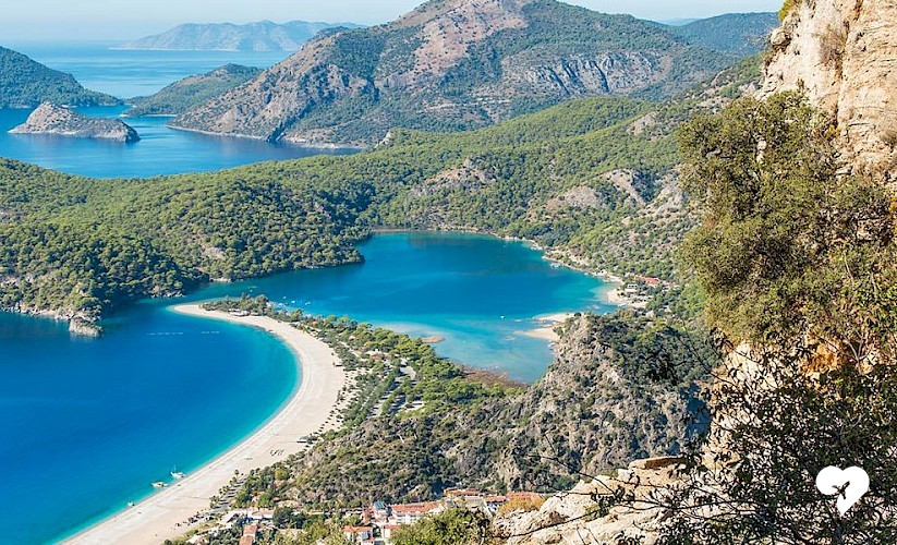
I can't do it all. If I do ONE bit, which bit should that be?

To each their own of course, but the best views are probably from Gelidonya Lighthouse, which was chosen as the best view in all of Turkey in 2007. Otherwise, the view over Ölüdeniz is, of course, breathtaking.
How difficult is it?
It’s not very challenging, the path is clearly marked and there’s no rock climbing or anything. It’s a great path for anyone excited about history and nature, so come discover the magic of the Lycian Way!